

Utah’s Window into the Global Flood

The Morrison Formation, Marine Evidence, and Catastrophic Burial
Standing at the Wall
When you stand at the Quarry Exhibit Hall in Dinosaur National Monument, just east of Vernal, Utah, the rock wall in front of you is not a quiet museum display. It is a frozen catastrophe. More than 1,500 dinosaur bones remain locked in the sandstone, many still in partial articulation, as if the animals were swept together and buried before they could even decompose. The wall itself is tilted nearly 67 degrees. That tilt is later uplift. The burial happened first.
This is Utah’s place in the global Flood.

A Discovery in the Utah Desert
On August 17, 1909, Earl Douglass of the Carnegie Museum was walking the ridges of the Morrison Formation near Jensen, Utah. He had been sent west to find a show-stopping sauropod for the museum’s halls. After weeks of frustration he climbed a saddle between two hills and saw eight tail vertebrae of an Apatosaurus lying in exact position. “It was a beautiful sight,” he wrote in his journal. Those bones belonged to what would be named Apatosaurus louisae.
Over the next thirteen years Douglass and his crew removed more than 350 tons of fossils: Camarasaurus, Diplodocus, Stegosaurus, Allosaurus, Barosaurus, and others. In 1915 President Woodrow Wilson set aside the quarry as Dinosaur National Monument. The in-place wall we see today is the remainder of that original hillside. The Carnegie excavations were part of the larger western dinosaur rush that followed the Bone Wars of the late 1800s. Utah quickly became one of the richest windows into these mid-Flood graveyards, later joined by Cleveland-Lloyd and many other Utah quarries.
The Vast Morrison Formation
The rock that holds them is the Morrison Formation. Named for the town of Morrison, Colorado, it is one of the most extensive sedimentary units in North America. It covers roughly 600,000 square miles, stretching from southern Canada through Montana, the Dakotas, Nebraska, Kansas, the Oklahoma and Texas panhandles, New Mexico, Arizona, Idaho, Wyoming, Colorado, and Utah. In Utah it is especially well exposed in the San Rafael Swell, Capitol Reef, the Henry Mountains, the Uinta Basin, and around Moab.
Conventional geology assigns it to the Late Jurassic and describes it as a patchwork of rivers, floodplains, and seasonal lakes that accumulated over millions of years. The rocks themselves tell a different story. A river system cannot lay down the same sand and clay beds, the same colors, and the same thin marker layers across eleven states and parts of Canada.

The Morrison Formation blankets about 600,000 square miles. Utah sits near the heart of this deposit.
Members of the Morrison in Utah
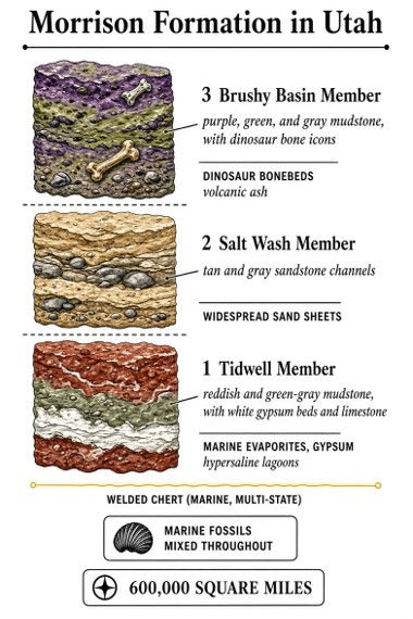
The Morrison is typically 180 to 400 feet thick, a stack of varicolored mudstones, siltstones, sandstones, and thin limestones in distinctive purples, greens, grays, reds, and almost-white layers. God color-coded the geology for us. In Utah the formation is divided into three main members.
• Tidwell Member (base). Red and greenish-gray mudstones with sandstone lenses, limestone, and beds of gypsum. Those gypsum beds formed in hypersaline, evaporative conditions. Gypsum of this extent does not form in ordinary freshwater rivers.
• Salt Wash Member (middle). Dominated by channel sandstones and conglomerates that conventional workers call braided-stream deposits. In the Flood they are better understood as widespread, high-energy sand sheets.
• Brushy Basin Member (top). The mudstone-rich interval that holds most of the dinosaur bonebeds, including the Carnegie Quarry and the Cleveland-Lloyd Quarry farther south in Utah. Volcanic ash is mixed through these mudstones.
The Marine Context
The problem with the slow-river story is that these supposedly terrestrial rocks contain a persistent marine signature. The lower Morrison is full of ocean rocks and marine fossils: fish, oysters, crabs, snails, brachiopods, ammonites, and dinoflagellates. Glauconite sands appear. Rippled limestone beds up to tens of feet thick occur.
A thin welded chert layer, only half an inch to three inches thick, can be traced across Utah, Colorado, Kansas, Nebraska, New Mexico, South Dakota, and Wyoming. Chert of this kind forms from silica-rich marine waters. These marine indicators are not confined to isolated pockets. They are mixed throughout the unit, including in the same intervals that contain the land animals.
Gypsum in the Tidwell Member is especially telling. It records hypersaline water, not a quiet freshwater floodplain. When marine or highly saline waters inundate a broad basin and precipitate evaporites over a regional scale, the result looks like what we see at the base of the Morrison in Utah.
Evidence of Catastrophic Burial
Rivers carve sinuous, narrow channels inside floodplains. They do not mix marine shells and glauconite with dinosaur carcasses over hundreds of thousands of square miles. They do not produce the density of bone we see at Dinosaur National Monument or Cleveland-Lloyd, where skeletons are jumbled together like a logjam.
Rapid burial is required to keep bones articulated and to prevent scavengers from completely disarticulating the remains. Many of the Carnegie Quarry specimens are partially articulated or nearly complete. That is the signature of sudden, high-energy burial, not years of seasonal drought followed by gentle rains.
The Flood supplies the mechanism: successive, high-energy waves and tsunamis as the waters rose, sweeping marine water onto the land, mixing sediments, and burying animals that had been living at different elevations. Volcanic ash from the catastrophic plate motions of the Flood is mixed into the Brushy Basin mudstones. The same event that opened the fountains of the deep also produced the volcanism that dusted these layers.
Utah and the Zuni Peak of the Flood
Flood geologists have long recognized that the sedimentary record of North America is organized into a handful of continent-scale packages called megasequences. From oldest (early Flood) to youngest they are the Sauk, Tippecanoe, Kaskaskia, Absaroka, Zuni, and Tejas. Each records a major pulse of rising and then receding water as the Flood progressed.
The Morrison sits at a critical place in that stack. It is conventionally labeled Late Jurassic. The layers immediately above it are Cretaceous marine rocks of the Western Interior Seaway. Those Cretaceous deposits, together with the Morrison beneath them, belong to the Zuni megasequence. Research by Flood geologists, including the work discussed by Dr. Tim Clarey, identifies the Zuni as the peak of the Flood: the time when the waters reached their greatest extent over the continents.

Utah therefore records the moment when rising Flood waters overtopped the remaining high ground of the Western Interior. Land animals were drowned and buried as marine water mixed across the landscape. Then the waters rose still higher and deposited the thick marine package of the Western Interior Seaway above the Morrison. That is why the Morrison can look “terrestrial” in places and still carry marine fossils, gypsum, glauconite, and a multi-state chert bed. It is the transition into the peak.
A simple reading of the Zuni stack
Table 1. The Morrison sits at the door of the Zuni peak.
Interval | What we see | Flood meaning |
Tejas (youngest) | Late receding deposits | Waters draining off the continents |
Zuni peak | Cretaceous Western Interior Seaway | Maximum Flood coverage of the land |
Onset of Zuni | Morrison Formation (Utah dinosaur graveyards) | Waters overtopping high ground; mixed marine and land burial |
Absaroka to Sauk | Earlier Flood megasequences | Progressive rise from the fountains of the deep |
After the Waters Receded
After the waters reached their peak, the continents rose and the waters receded. In Utah that recession, combined with later uplift of the Colorado Plateau and the Rocky Mountains, exposed the Morrison in the colorful badlands we see today.
The Green River cutting through Split Mountain, just north of the quarry, is another testimony. Receding Flood waters found the cracks in still-soft, recently deposited sediment and ripped the canyon open. The small river that occupies the canyon now did not have the power to do that work. The same pattern appears across the Colorado Plateau: great thicknesses of Flood sediment, then rapid incision as the waters drained.
What the Rocks Testify
Utah occupies a special place in the Flood record. The Colorado Plateau’s later rise has given us some of the clearest windows into these mid-Flood layers. The same rocks that hold the dinosaurs also hold the marine evidence that the water covering them was not a local river but the waters of the great deep and the windows of heaven.
Genesis 7:19–20 tells us the waters prevailed exceedingly upon the earth and all the high hills were covered. The Morrison is one of those covering layers, laid down as the Flood reached its climax over what is now the American West.
The bones in the wall at Jensen are not a puzzle of slow droughts and seasonal floods. They are a record of judgment and of the faithfulness of God’s Word. The same God who judged the earth in Noah’s day provided the Ark. He has provided a greater Ark in Jesus Christ.
The rocks of Utah, like the rocks of the Grand Canyon and so many other places we have visited, keep pointing us back to that hope. Keep studying the evidence. It all testifies of Him.

Comments